ESA Swarm mission: An overview
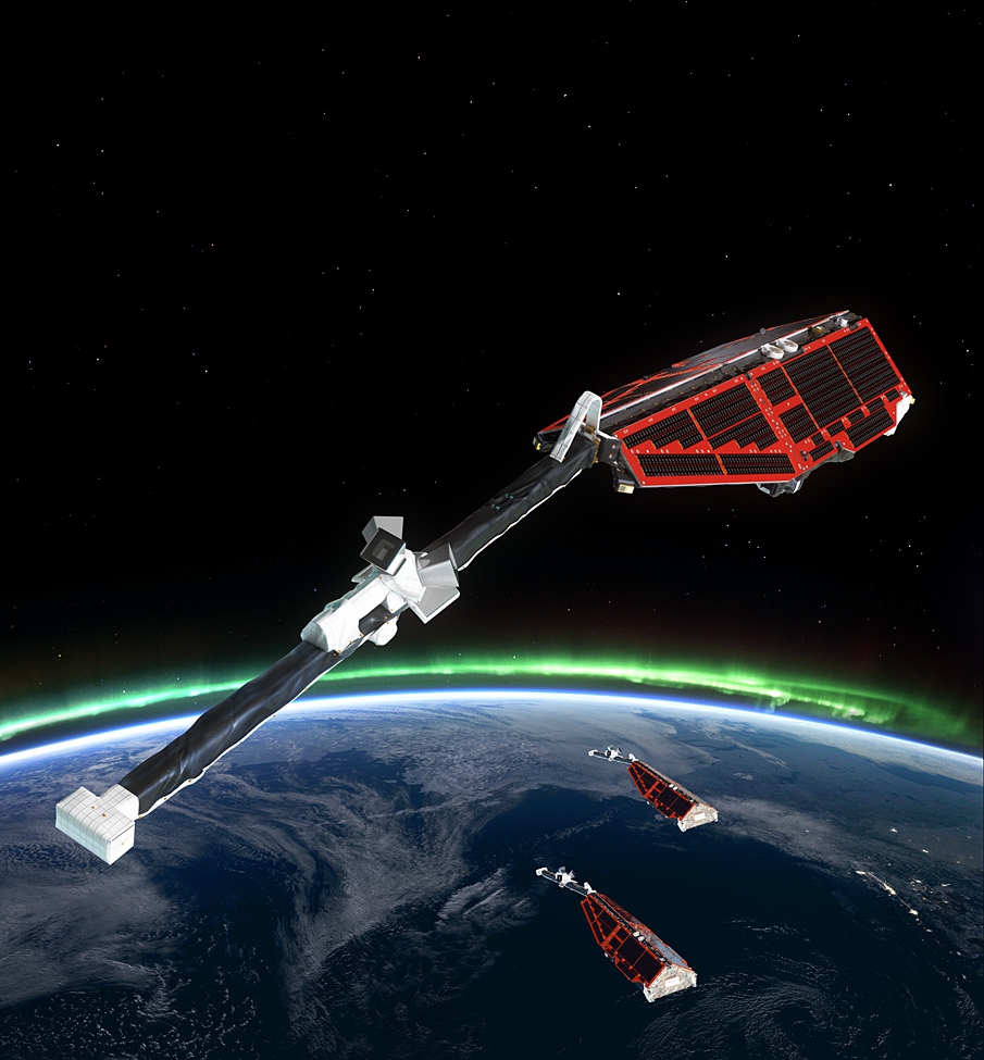
The European Space Agency (ESA) launched a new satellite mission called Swarm on 22nd November 2013. The mission consists of three identical satellites which will measure the strength and direction of Earth's magnetic field to new levels of precision. The new data will be processed by BGS to produce the most accurate maps of the Earth's magnetic field ever.
Earth's Magnetic Field
The magnetic field we measure comes from four main sources - the main field from the Earth's core, the field from the Earth's crust (magnetic rocks), the upper atmosphere (ionosphere) and the interaction of the Earth and the Sun's magnetic fields (magnetosphere).
A unique satellite configuration
In order to best measure the field, the satellites will orbit in a unique configuration. Two satellites will fly side-by-side at height of 450 km, while the third satellite will fly at an altitude of 530 km. The lower two satellites will allow very fine measurements of the magnetic field generated by the rocks in the Earth's crust, which are difficult to detect otherwise. The upper satellite will give a simultaneous measurement at a different location. This is important for identifying magnetic fields generated by the magnetosphere and ionosphere.
Better models
The combination of all three satellites will provide better maps and models of the main field which are primarily used for navigation purposes (e.g. for shipping, in smart phone map applications, or directional drilling for oil and gas). The measurements will help us better understand the impact of space weather events on technology such as satellite communications and GPS accuracy.
Satellite instrumentation
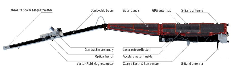
Each satellite is nine metres long, which a main body covered in solar panels and a four metre boom on which the sensitive magnetic field measuring instruments sit - away from electrical and magnetic interference. The magnetic field is measured by two instruments - (1) by the scalar instrument at the end of the boom which measures the strength of the field and (2) the vector instrument in the middle of the boom, which measures the direction of the field, using star cameras for accurate orientation of the satellite.
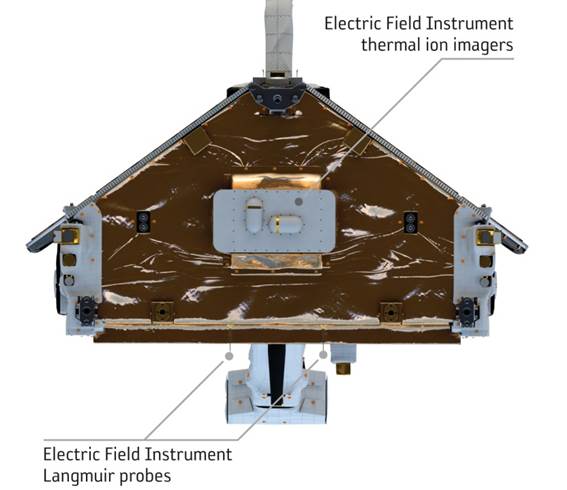
The satellites also measures the electric field in the ionosphere using novel Langmuir probes and an electric field instrument sited on the front of the satellite, giving a full physical measurement of the field in the upper atmosphere for the first time.
Satellite orbits
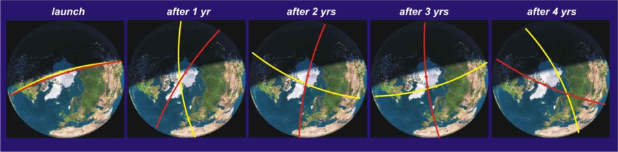
All three satellites are polar-orbiting allowing them to survey almost the entire planet (except for a small polar gap). The satellites are all launched together on the same rocket to about 500 km height. Soon after launch, the lower two satellites (named Swarm A and Swarm B) will drop to 450 km altitude while the third (Swarm C) will be raised to 530 km. The effect is to cause the orbital planes of the satellites to precess around the Earth at different rates. After two years, the orbital planes of the upper and lower satellites will be approximately perpendicular to each other. This allows the entire Earth to be sampled more quickly and to identify the sources of the magnetic fields better.
Data availability
The data will be provided for free by ESA on their website. In addition, ESA have commissioned BGS and five other European research institutes to produce specific types of magnetic field maps, models and processed data for the general public. In the UK, several universities and research institutes will be involved in the scientific research over the mission lifetime. The BGS Geomagnetism team have spent the past three years preparing for the launch of Swarm.

- Independent validation of Swarm Level2 magnetic field products and 'Quick Look' for Level 1b data (2013)
- The Swarm Satellite Constellation Application and Research Facility (SCARF) and Swarm data products (2013)
- Observatory data and the Swarm mission (2013)
- Ionospheric mid-latitude electric current density inferred from multiple magnetic satellites (2013)
- A rapid model of the large-scale magnetospheric field from Swarm satellite data (2012)
- What the Swarm mission may tell us about the South Atlantic Anomaly (2012)
- The role of geomagnetic observatory data during the Swarm mission
- Investigation of decadal scale changes in the auroral oval positions using Magsat and CHAMP data
- Correcting observatory data prior to scientific analyses
- Near real-time characterisation of auroral activity using satellite magnetic data
- SCARF - The Swarm Satellite Constellation Application and Research Facility
